Multiday severe weather outbreak threatens 60 million from border with Mexico to Canada
A three-day severe weather outbreak threatens to bring damaging winds, large hail, flooding and strong tornadoes to a vast region in the Central U.S.
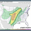
The big picture: The storms may peak on Saturday, when the threat area will extend from the Gulf Coast to Wisconsin and tornado danger may be highest.
The latest: A powerful tornado went through the western part of the city of Omaha, Nebraska, with early reports of major damage. Tornado emergencies were in effect at the time.
- Weather spotters also confirmed a "large and destructive tornado" near the village of Shelby in Nebraska, and the NWS Omaha/ Valley Nebraska issued a tornado warning advising of "a life-threatening situation" and damage to homes and businesses.
- Building damage has already been reported at Garner Industries, a plastic injection molding company in Lancaster County, Nebraska, which had 70 workers inside, per KOLN news station.
Driving the news: The storms will affect a broad section of the Plains, Central states and Midwest, with the National Weather Service noting heightened concern on Saturday for a "widespread" outbreak of severe weather, potentially including powerful tornadoes.
- The severe thunderstorm outbreak will affect tens of millions and multiple cities, including Oklahoma City, Wichita, Des Moines, Kansas City, Dallas and Omaha all the way to Madison, Wis.
- Multiple days of moisture-rich air flowing northward from the warmer-than-average Gulf of Mexico, combined with slow-moving thunderstorms, could yield significant flash flooding as well, particularly in parts of Oklahoma on Saturday.
Threat level: On Friday, the Storm Prediction Center issued an "Enhanced" threat outlook for severe weather, which is a level 3 out of 5 on its scale, for parts of Iowa, Nebraska, Kansas and Missouri.
- The level 3/5 outlook expands Saturday and shifts east, while a vast region is designated as having a slight, or level 2/5, risk for severe weather.
Context: Climate change is affecting the atmospheric conditions that give rise to severe thunderstorms, in particular by increasing instability.
- Some studies show a warming climate can make tornado outbreaks more prolific, but potentially frequent.
- Climate science shows robust links between heavy rainfall events and a warming climate, since warm air holds more water vapor.
How it works: The multiple rounds of severe weather are being triggered by storm systems and their associated frontal zones, along with disturbances in the jet stream.
- Computer models have consistently been showing the potential for high instability to overlap with significant wind shear in a way that increases the tornado threat, although uncertainties remain.
- "Numerous severe thunderstorms are likely Saturday into Saturday night. The greatest severe threat is currently anticipated across parts of the central and southern Plains, where very large hail, damaging winds, and multiple strong tornadoes will be possible," the NWS' Storm Prediction Center stated in a forecast discussion on Friday afternoon.
What's next: The severe weather is expected to peak each day in the afternoon and evening hours, though in some spots it could rumble well into overnight, presenting when tornadoes can be especially deadly.
Editor's note: This story has been updated with the latest weather conditions.