Tens of millions from Kansas to Iowa face severe thunderstorm threat
Some 45 million Americans are at risk of severe thunderstorms from Nebraska through parts of the Midwest and south-central states from Tuesday through Thursday.
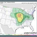
The big picture: The National Weather Service's Storm Prediction Center issued an enhanced risk (level 3/5) of severe thunderstorms for parts of Iowa, northern Missouri and Illinois Tuesday.
- As of early afternoon Tuesday, tornado watches covered nearly all of Iowa, northern Missouri, and western Illinois, indicating the conditions were favorable for the formation of tornadoes, among other severe weather hazards.
- Des Moines, Cedar Rapids, Davenport and Iowa City are each in the enhanced storm risk zone Tuesday into Tuesday night.
What they're saying: "These storms will pose a threat for very large hail, damaging winds, and tornadoes, including the risk for a strong tornado," the NWS warned in a forecast discussion Tuesday morning.
Zoom out: On Sunday evening, a line of damaging severe thunderstorms struck much of Pennsylvania. While April typically marks the start of severe weather season in much of the U.S., this was unusually early for such a damaging line of storms so far north and east.
Context: While it does not get the same amount of attention as tornadoes do, large hail can cause large economic losses from damaged cars, homes and crops.
- Last year such losses were notably high across the U.S., costing insurers billions.
- Storms with large, damaging hail, high winds and possible tornadoes were more likely from Texas northward into Nebraska through Monday night, where watches went into effect.
- On Monday afternoon, severe thunderstorms with half-dollar-sized hail blew through the D.C. suburbs in northern Virginia, and those storms subsequently took aim at Richmond.
Between the lines: Above average air temperatures have enveloped the Plains, Midwest and portions of the Mid-Atlantic ahead of an area of low pressure moving eastward into the Midwest.
- Highs in the 70s and 80s will be widespread across the severe weather region, and throughout an even broader area beyond it, the NWS stated.
What we're watching: The SPC noted in its discussions that the exact extent and severity of the tornado risk in particular was uncertain, as some, but not all, of the ingredients for a widespread severe weather outbreak looked to be present Tuesday.
The bottom line: Climate change is increasing the frequency and magnitude of precipitation extremes, studies show.
- It is also making heat waves more likely, intense and longer lasting.
Go deeper: Pittsburgh streets flooded as severe storms threaten Ohio Valley, Mid-Atlantic
Editor's note: This story has been updated with the latest forecast information.