Weather Alert Overnight
Published Date: 3/26/2024
Source: WDSU News
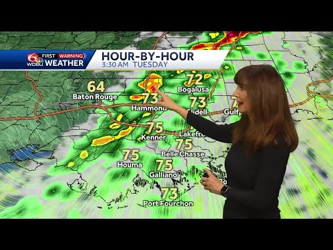
Scattered rain and windy this evening with temps in the 70s. Wind advisory posted through 4 AM. Wind may gust to 45 mph. Gale warning through 4 AM. Coastal Flood Advisory for Southeast facing shorelines. Water rise of 1-2 feet above sea level is possible. Strong storms are possible in the early morning. Timing is about 1 AM to 6 AM. A broken line of rain and storms will move from West to East across the area. There is the risk for an isolated tornado. The risk for strong long track tornadoes is to our North in Mississippi. There is the risk for strong gusty winds in storms. The rain moves out and the weather improves Tuesday with sunny skies later in the day. Highs will be in the upper 70s to near 80. Another cold front moves through with slightly cooler and less humid weather Wednesday through Friday. Warmer this weekend. Highs low 80s Easter Sunday.
Subscribe to WDSU on YouTube now for more: http://bit.ly/1n00vnY
Get more New Orleans news: http://www.wdsu.com
Like us: http://www.facebook.com/wdsutv
Follow us: http://twitter.com/wdsu
Instagram: https://www.instagram.com/wdsu6/