La Niña odds increase, adding to Atlantic hurricane season concerns
The tropical Pacific Ocean is in the process of lurching from a strong and planet-warming El Niño to a cooling La Niña, according to new data released Thursday.
Why it matters: La Niña events may supercharge the Atlantic hurricane season, while also somewhat reducing global average surface temperatures.
Driving the news: A new NOAA forecast increases the odds for both a rapid transition to "El Niño-Southern Oscillation neutral conditions" (when neither El Niño nor La Niña are present) during the next two months and the development of La Niña as early as the June through August period.
- Compared to the previous outlook released on Feb. 8, the odds of a La Niña have increased.
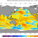
- In fact, an area of cooler-than-average waters has already emerged along the eastern equatorial Pacific Ocean, with cooler-than-average waters also lurking beneath the ocean surface across a larger portion of the tropical Pacific.
How it works: La Niña episodes feature cooler-than-average waters in the central and eastern tropical Pacific. They can reduce upper-level winds across the Atlantic during hurricane season.
- This decreases atmospheric wind shear; in turn, it tends to favor the development and intensification of tropical storms and hurricanes.
By the numbers: According to the new outlook, El Niño is already making a quick exit.
- The outlook projects a transition to ENSO-neutral conditions during the spring, with an 83% chance of ENSO-neutral conditions during the April through June period.
- The forecast shows a 62% chance — up from 55% in the February outlook — of a La Niña developing during the June through August period.
- By the August through October period, which is the peak of the Atlantic hurricane season, the new outlook shows an 82% chance of a La Niña event.
Context: NOAA's outlooks show a remarkably quick switch away from El Niño, but experts told Axios this has been seen before with strong events.
- "Big El Niños especially can end abruptly, creating conditions favorable for a rapid onset of La Niña," Michael McPhaden, a NOAA senior scientist, told Axios via email. "One way to think about the El Niño to La Niña transition is in terms of a playground swing."
- "The higher up you are on the backswing (El Niño), the faster you'll come down and your momentum at the bottom of the swing will propel you quickly forward and upward (La Niña)," McPhaden said.
Between the lines: La Niña is not the only factor worrying hurricane forecasters. Ocean temperatures in the tropical Atlantic are at the highest level on record for this time of year, and it is looking less likely that they will moderate before the hurricane season starts on June 1.
- It is possible that most seasonal outlooks due out in the next few weeks will call for unusually high numbers of storms, including the number of "major" hurricanes (Categories 3 and above).
What they're saying: "This is new for everyone," Brian McNoldy, a hurricane researcher at the University of Miami, told Axios about the conditions setting up for this season.
- "We haven't experienced a strong La Niña combined with Atlantic water temperatures that are this anomalously warm," he said. "At a basic level, that combination would make for a very active Atlantic hurricane season, since both of those factors individually act to nudge it upward," he said.
- "Zooming in a little, we'd be more likely to see activity begin earlier in the season than normal and then during the heart of the season, we'd be more likely to see stronger storms and potentially more instances of rapid intensification," McNoldy said.
Yes, but: The development of La Niña is not certain, and forecasts made at this time of year can be less accurate due to what meteorologists call the spring predictability barrier.
- This refers to the difficulty of predicting El Niño and La Niña during the spring for the following fall.
The intrigue: Right now, though, forecasters are more confident than they would typically be at this time of year.
- And if a La Niña does set in, it would likely knock global average surface temperatures back from their record levels, potentially causing 2024 to come in second to 2023 on the list of warmest years.