Sierra Nevada faces 12 feet of snow, 100mph winds in extreme California blizzard
A "potentially life-threatening," blizzard is slamming the Sierra Nevada with up to 12 feet of snow — making mountain travel "extremely dangerous to impossible" into the weekend, the National Weather Service warns.
The big picture: This "extremely potent" winter storm also threatens the higher terrain of Washington and Oregon, parts of the Great Basin and Rockies as well, per an NWS forecast discussion Friday.
Conditions continue to deteriorate along I-80 this evening as hourly snowfall rates and winds increase. A Blizzard Warning remains in effect through Sunday for areas above 2000 ft in the Sierra. Travel is *HIGHLY* discouraged!! #CAwx pic.twitter.com/fdSSUpwdkd
— NWS Sacramento (@NWSSacramento) March 1, 2024
However, no region is in the crosshairs like the northern and central Sierra Nevada, the NWS stated Friday morning.
- "Extreme snowfall totals of 5-12 feet (locally even higher) are forecast through the weekend, with high snow rates and winds leading to blowing/drifting snow and whiteout conditions, making travel impossible," forecasters wrote.
- Satellite images showed high, fast-moving clouds associated with the jet stream streaming across the region, with mid-level clouds associated with the blizzard flowing in from the Pacific.
Threat level: There are already numerous road restrictions and closures on mountain roadways in the Sierra, and residents and travelers are being told to stay put to avoid getting stuck in a raging blizzard.
- The NWS issued rare blizzard warnings for the Sierra, Northeast Foothills, Motherlode and the western Plumas and Lassen area from 4am Thursday through 10am Sunday.
- Unusually, the blizzard warnings extend to the Lake Tahoe area.
- Expected snowfall rates of 2-4+" per hour and frequent wind gusts 55 to 75 mph or greater "will combine to bring whiteout conditions with near zero visibility at times," with "extensive tree damage and extended power outages" likely, per an NWS Sacramento office forecast discussion.
- "Travel over Sierra passes has already become treacherous and will only deteriorate as we go into the weekend," the NWS forecast office in Reno stated early Friday.
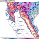
By the numbers: "Storm total snowfall from Thursday into early Sunday is currently projected at 5 to 10+ feet for elevations above 5,000 feet, locally higher amounts of 12+ feet are possible at peaks, with significant disruptions to daily life likely," the NWS' Sacramento office said.
- These snowfall amounts, of well over 100 inches in just four days, are some of the highest made in modern forecasting for the northern and central Sierra.
- While heavy snow typically falls there, this storm will be stuck in place, directing a steady plume of extremely heavy snow and screaming winds at the mountain range for days.
- Winds are likely to top 100 mph at the highest elevations.
- The Tahoe Basin was expected to see 4-8 feet of snowfall at elevations 7,000 feet above sea level, and 2-4 feet of snow could be dumped on towns in the Lake Tahoe area.
Blizzard conditions are expected in areas above 2000 ft this afternoon through Saturday. It is EXTREMELY dangerous to travel through the mountains at this time! AVOID travel! Stay up to date with the forecast at https://t.co/7FMe5twj20 by entering your zip code. Stay safe! #CAwx pic.twitter.com/ANf1qmEmBe
— NWS Sacramento (@NWSSacramento) February 29, 2024
Yes, but: A relative lull in precipitation overnight and into early Friday morning in parts of the northern Sierra could keep some of the astronomical snow totals above 12 feet from being reached.
Between the lines: The snowfall will help bring Sierra snowpack closer to average for this time of year, after it fell slightly behind.
- "Overall, precipitation for the past 90 days has been above average essentially everywhere within 100 miles" of California's coast and "near to slightly below average inland across the Sierra Nevada," UCLA climate scientist Daniel Swain wrote in a blog on Wednesday.
- In general, Swain said the December to February period "will end up warmer and wetter than average" for most of California's land area and the vast majority of its population, and January to March "precipitation anomalies may yet be even higher on the wet side."
Context: Studies show that climate change is increasing the frequency and magnitude of heavy precipitation events.
- El Niño has combined with climate change to drive historic storms that have hit California this winter, according to Swain and other climate scientists.
Go deeper: Winter whiplash: Why a parade of storms is suddenly slamming the U.S.
Editor's note: This article has been updated with more details on the storm and further context.