La Niña watch issued as El Niño fades, with global implications
The National Oceanic and Atmospheric Administration (NOAA) issued a La Niña watch on Thursday morning, indicating that the current strong El Niño may be headed for the exits.
Why it matters: If the tropical equatorial Pacific Ocean shifts into its cooler La Niña phase, a cascade of extreme weather and climate impacts could be touched off worldwide.
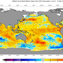
Zoom in: The El Niño still underway features milder-than-average ocean waters in the tropical Pacific and associated shifts in the atmosphere. There are increasing signs that a transition is afoot.
- A "watch" means that conditions are favorable for the development of La Niña within the next six months.
- In its new forecast discussion, NOAA states there is now a 79% chance that El Niño will shift to "ENSO-neutral" conditions (without either El Niño or La Niña) by the April through June period.
- And it notes "increasing odds" that La Niña will develop during the summer months of June through August, with about a 55% chance during that period.
Threat level: By the September through November period, the forecast calls for a 77 % chance of a La Niña developing.
- A potential La Niña present during spring and summer is significant, because these events tend to create more favorable conditions for hurricanes to form and intensify.
- Specifically, they can reduce the prevalence of wind shear, which occurs when winds blow with different speeds and/or direction at different altitudes across the tropical Atlantic Ocean.
- Some of the busiest seasons on record have occurred during La Niña years.
- La Niña events also affect the U.S., among other regions. They tend to favor drought along the southern tier of the Lower 48 states, including the Southwest through Texas.
Of note: As an added hurricane season concern, sea surface temperatures across the tropical Atlantic are running above average and may stay elevated heading into the warm season.
The big picture: The added ocean heat and its release to the atmosphere associated with El Niño has provided an extra boost to global average temperatures, on top of the human-caused global warming trend.
- This extra warming helped 2023 become the hottest year on record, though the human-caused warming was a far larger factor.
- La Niña features below-average sea surface temperatures in the tropical equatorial Pacific Ocean and tends to cool global average temperatures slightly.
Yes, but: A rare "triple dip La Niña" from 2020-2023 never managed to knock global average surface temperatures out of a top 10 ranking, said Michelle L'Heureux, a physical scientist at NOAA's Climate Prediction Center.
- The onset of La Niña would suggest that 2024 may not beat out 2023 for a new hottest year ranking.
- Still, L'Heureux cautioned that the tropical Pacific Ocean will release huge amounts of heat between now and La Niña's official onset, which may keep temperatures elevated for a longer period.
What they're saying: "I think a La Niña event developing this summer would tend to suppress global temperatures during the last quarter of the year," climate scientist Zeke Hausfather told Axios, via email.
- "Either way, 2024 is going to be exceptionally warm, but if we have a La Niña develop it may end up a bit cooler than 2023's record."
Between the lines: The new NOAA discussion notes that the shifts are happening under the sea surface and in the atmosphere above that are reflective of a diminishing El Niño.
- For example, instead of a reservoir of warmer-than-average waters well below the surface (which would reinforce El Niño's surface ocean temperature signal), the subsurface has cooled considerably in just the past month.
- While a transition from one phase to the next may seem sudden and unexpected, L'Heureux told Axios there is a historical tendency of La Niña events to follow soon after strong El Niño episodes.
- "Essentially the Tropical Pacific system has overheated and now we're coming off the peak," she said. "And when we come off the peak, there is a certain degree of momentum. And sometimes that momentum is strong enough that you shoot into a La Niña."
The bottom line: For hurricane forecasters and those who predict global climate trends, all eyes will be on the tropical Pacific during the next few months.