Why the recognizable National Hurricane Center forecast cone is changing
The National Hurricane Center is testing a new forecast graphic to replace the familiar "cone of uncertainty."
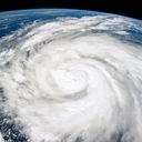
Why it matters: The cone of uncertainty graphic, which dates to 2002, shows the probable track of the center of a storm and does not include the extent of its hazards. This risks downplaying a storm's impact.
2/1 at 9am: The National Hurricane Center (@NHC_Atlantic) will be implementing a new experimental cone graphic beginning on or around August 15th 2024.
— NWS Miami (@NWSMiami) February 1, 2024
This experimental graphic will help better convey wind hazard risk inland in addition to coastal wind hazards. pic.twitter.com/pDkNiRoupx
- The new, experimental graphic is expected to be available around mid-August.
The big picture: The NHC will implement this experimental graphic during the upcoming hurricane season in order to"better convey wind hazard risk inland in addition to coastal wind hazards," the NWS forecast office in Miami, where NHC is based, said in a post to X Thursday.
- Studies show that the 20-year-old cone graphic is often misunderstood.
- The cone is probabilistic, meaning that there's a two-thirds likelihood that you'll see a direct hit from a landfalling storm if your town is within the cone.
- But that doesn't mean you won't be affected if you live outside of it.
The width of the cone is set by the error rates from the previous five years of storm forecasts.
- Research from the University of Miami found 40% of people don't feel threatened if they live outside the cone, despite these large storms' wide array of impacts.
Context: Research shows climate change is causing hurricanes to grow more intense more quickly as it also plays a major role in warming ocean temperatures — and climate change-related sea level rise is making surge-related flooding more damaging.
- Hurricane Ian rapidly intensified over extremely warm sea surface temperatures straight through landfall as a high-end Category 4 storm in Florida in 2022.
- The storm caught many off guard as it killed 149 people in the state and five others in North Carolina and one more in Virginia and there was significant confusion over the cone of uncertainty in the lead-up to landfall.
Zoom in: In Lee County, Fla., where Ian killed 72 people, storm survivors told media they thought the core of the hurricane was headed for Tampa, based on previous forecasts.
- Federal, state and local officials were quoted as saying the county was not in the cone 72 hours before landfall.
- That's despite the NHC consistently emphasizing uncertainty and the need to focus on more than the centerline in its cone graphics, as well as that region being in the cone, just not near the centerline.
- The storm continued to dump heavy rain across Florida, flooding many communities near rivers that may not have expected to be affected.
Of note: The new graphic still does not depict the inland flood threat, but the Hurricane Center may find a way to incorporate that in the near future.
Between the lines: Laura Myers, who studies storm risk perception at the University of Alabama, told Axios after Hurricane Ian struck that some who did find out the growing risks and predicted impacts chose not to evacuate, since this is a complicated decision involving much more than the weather.
Go deeper:
Drones and satellites are making better, life-saving hurricane forecasts
Inside an airborne quest to predict Lee, and other hurricanes