Strong atmospheric rivers poised to affect California
A one-two punch of strong atmospheric rivers threatens to dump heavy rain and snow in California during the next 10 days, with flooding likely.
Why it matters: The state's mountain snowpack is running well below average for this time of year, and this wet pattern could change that.
- Over the longer term, human-caused climate change is expected to result in atmospheric rivers that carry more moisture and are capable of dropping heavier amounts of rain and snow.
- This would exacerbate flooding challenges and test infrastructure built to withstand a historical climate that no longer exists.
Zoom in: After the storm set to begin Tuesday in northern California, additional, potentially heavier rain with the second anticipated system late next weekend may carry the risk of significant flooding.
- Some computer model guidance is showing the potential for Los Angeles, for example, to pick up nearly its annual average rainfall during the next week.
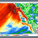
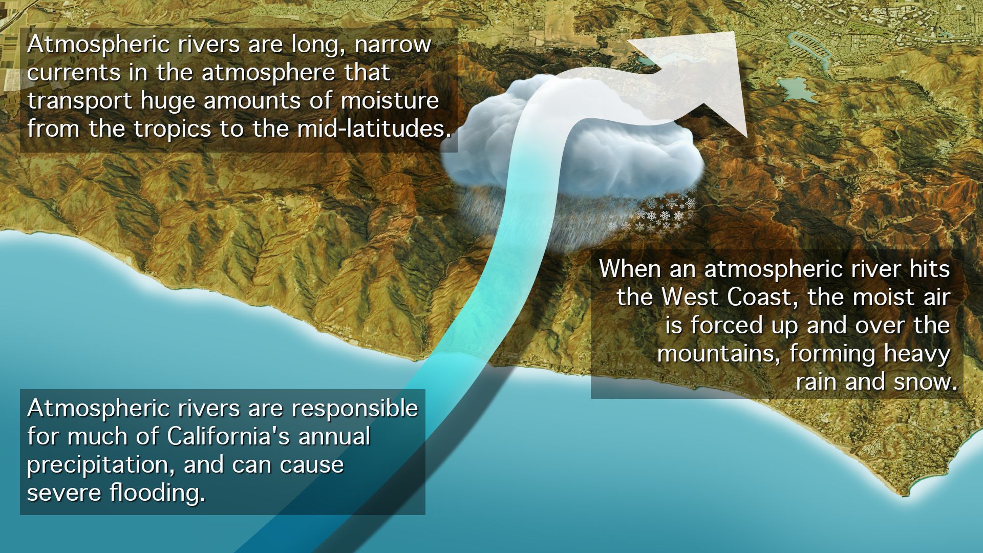
The big picture: Atmospheric rivers are highways of concentrated water vapor located in the middle atmosphere, about 10,000 to 20,000 feet above the surface.
- They can stretch for thousands of miles, channeling water from the subtropics to more temperate regions.
- The first atmospheric river moving into California has ties all the way to Hawaii and will tap into energy from across the other side of the vast Pacific Ocean.
Of note: Its Hawaiian roots are why meteorologists refer to the system as a "Pineapple Express" storm.
- For more than a week, a powerhouse, unusually straight west-to-east flowing jet stream has been screaming across the Pacific. It's propelled passenger aircraft from Asia to the U.S. at near-record speeds and set up an ideal weather pattern for heavy rain and snow to fall out West.
Context: Warmer than average ocean temperatures in much of the tropical and northeastern Pacific, which are partly tied to El Niño, are likely to add more moisture to both storm systems.
- This has already been demonstrated, with damaging results, during other storms so far this season.
- Extreme precipitation events are already becoming more common and severe across the U.S. and other parts of the world, which studies have tied to a warming climate.
Threat level: The first incoming system is already hitting British Columbia. As it slides south, across the Pacific Northwest and into Northern California, it may rank as an AR4, at the higher end of a five-point scale.
- Flood and high wind watches are already in effect for parts of the West Coast, including the Sacramento Valley and San Francisco Bay region. In terrain-favored areas, between 5 to 8 inches of rain could fall, while about 1 to 3 feet of snow is expected in higher elevations of the Sierras.
- According to the National Weather Service, the storm is likely to bring its heaviest rains to Northern California, including the Bay Area.
- Due to recent precipitation, there is a growing threat of landslides with additional heavy precipitation, the NWS warns.
Between the lines: Southern California, which has seen two record-setting downpours so far this winter — one in Ventura in December and the other last week in San Diego — will also see heavy rain on Thursday into Friday.
- Thunderstorms are also possible with this weather system, which could dump heavy rains in a short period of time.
- After dousing California, this storm will stream into the Southwest and mountain West, bringing heavy rains to lower elevations and snow from the mountains of Arizona and New Mexico to Utah's Wasatch Range and east into the Colorado Rockies.
What's next: The second atmospheric river has the potential to be stronger and slower-moving than the first, particularly for Southern California.
- It will also find an even more waterlogged state when it arrives. This would amplify flooding concerns, especially in southern California.
- The NWS' Climate Prediction Center is forecasting a "high risk" of "hazardous, heavy precipitation" during the period from Feb. 6-9 across southern California and the Southwest.