Get ready for a warmup across the U.S.
With the U.S. in the grips of a record-breaking Arctic air mass, the prospect of a warmup may seem distant.
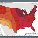
Yes, but: A significant weather pattern shift looks to bring air temperatures back into the above-average range for much of the country next week, after one more Arctic blast affects the Central U.S. and Southeast.
The big picture: The past two weeks have brought some of the coldest air in years to the Lower 48 states, with heavy snow and ice falling across more than half of the contiguous U.S.
- Hundreds of thousands of people have lost power in multiple states amid high winds, ice accumulation and frigid temperatures.
- In Tennessee, for example, Nashville had a high temperature of just 19°F, making it the first back-to-back days with highs below 20°F since Feb. 1996, per the NWS.
- "From the abyss that is the frozen tundra of Middle Tennessee, I bring you good tidings," the NWS forecast office in Nashville tweeted. "Next week is going to be a LOT WARMER than this week."
Zoom in: First up will be another Arctic blast that won't be quite as severe but will affect some of the same areas. It is expected to enter the Plains late this week and push south to the Gulf Coast this weekend, including throughout Florida.
What's next: After that, the North American weather pattern looks to be dominated by a much milder Pacific air flow, with above-average temperatures across most of the country.
- In fact, the end of January looks like it could end up with what forecasters refer to as a "torch" pattern, with temperatures well above average for this time of year.