Why winter storms are suddenly slamming the U.S.
The winter of 2023-24 has suddenly shifted from being delayed, with snow-starved ski areas and balmy northern cities, to highly active.
Driving the news: After a mild and tranquil start, a parade of storms are bringing cold and snow for millions, and rain and wind for others, all within a matter of days.
The big picture: The multiple winter storms crossing the country can be partially traced to weather patterns high above the Arctic, specifically the contortions of the polar vortex and a strong area of high pressure meandering near Greenland.
Yes, but: A new study published Wednesday found that over the long term, there is a detectable trend toward less spring snow cover in the Northern Hemisphere, including in many places where the liquid contained in the snowpack is crucial to water supplies.
- The study concludes that human-caused climate change is a major driver of these trends.
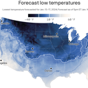
Zoom in: This year's winter whiplash is reflected in snow cover statistics. On Jan. 1, the area covered by snow in the Lower 48 states was just 20.3%, the lowest level for the date since such records began in 2003.
- That has since more than doubled, with 45.2% of the contiguous U.S. covered by snow on Jan. 10.
- In Minnesota, residents experienced a record-warm December, with average temperatures of 14°F above average.
- Now, though, the Twin Cities are preparing for a temperature nosedive to much colder than usual conditions. High temperatures will remain below zero Fahrenheit this weekend.
- Parts of North Dakota could see dangerous wind chills of minus 50°F.
Context: The shift to a colder, stormier weather pattern is tied to perturbations in the polar vortex, along with an unusually intense blocking pattern near Greenland.
- The polar vortex is an area of low pressure high above the Arctic, with winds that swirl counterclockwise around it. When the vortex's winds weaken, or its circulation is stretched as it is now, frigid cold usually confined to the Arctic can spill southward.
- Its circulation has been slowly weakening since early December, according to NOAA meteorologist Amy Butler.
- This culminated in what is known as a sudden stratospheric warming event around Jan. 6, she told Axios. Rapidly increasing temperatures at around 100,000 feet disrupted the vortex's circulation.
- This warming event, has helped to reinforce an area of high pressure over Greenland, also known as a blocking high. This feature has pushed the jet stream, located in the lower atmosphere, to the south and allowed cold air to follow.
According to meteorologist Jason Furtado of the University of Oklahoma, that high is now moving east to west, or "retrograding," which also favors more cold air intrusions into the U.S.
What they're saying: "You can picture the jet stream like a broad river of wind that separates cold air on the north from warm air on the south," Butler said.
- "The high pressure or 'blocking' over Greenland is like a boulder that has suddenly been dropped into this 'river of air' and diverts the flow so that the cold air is pushed southward."
- Butler says projections show the blocking will further disrupt the polar vortex, extending the cold and stormy pattern.
- In addition, there is also a long-lasting ridge of high pressure over Alaska. This too favors cold in the Central and Eastern U.S., Furtado said.
The intrigue: The storms that have been hitting the U.S. have been unusually potent.
- In Indianapolis, for example, the air pressure plummeted to a new January low on Tuesday. That record could be broken by an even stronger storm on Friday. (In general, the lower the air pressure, the stronger the storm.)
- Wind gusts from the most recent storm to strike the East Coast reached 79 mph and cut power to hundreds of thousands of customers.
- That storm delivered a deluge to the Washington region on Tuesday, breaking daily rainfall records, with Reagan National Airport recording 2.24 inches of precipitation in 24 hours.
- The next intense storm will qualify as a bomb cyclone, due to its rapid intensification rate, and more storminess is projected to take place next week, too, as the country stays cold.
Between the lines: Yet this is about more than just weird weather.
- For northerners and those who live in mountainous areas, cold and snow is part of their identity.
- Winter recreation powers local economies in ski resort towns, and snow cover also serves as critical water resources for millions.
- According to Axios Twin Cities reporter Nick Halter, Minnesota's winter recreation industry is welcoming the frigid air.
- "After December's warmth, many of the state's 10,000 lakes remain unfrozen, keeping anglers and skaters on the shore," he wrote via email.
- "Organizers of pond hockey tournaments, cross country ski races and other cold-weather events are hoping for even more cold and snow."
The bottom line: This winter is characterized by feast or famine snowfall across much of the U.S. According to the new study, such oscillations, with an overall decline in snowfall over time in certain regions, may soon become the norm as climate change from burning fossil fuels continues.
Jacob Knutson contributed reporting.