Extreme weather with multiple storms, polar vortex-related cold snap to slam U.S.
The next two weeks will feature multiple "powerhouse" storm systems and a polar vortex event that together will affect the U.S. from coast to coast, snarling travel, threatening lives and causing damage.
Threat level: The first storm is poised to bring multiple hazards from Monday through Wednesday, including a "ferocious blizzard" in the Plains, plus torrential rain, severe weather and high winds on the Gulf and East Coasts.
- Some of the upcoming extremes have clear ties to climate change.
The warm side of this first in a series of storms is where heavy rain, severe thunderstorms including a strong tornado risk, coastal flooding and widespread high winds are likely.
- This weather system is projected to propel an atmospheric river with record levels of water vapor for this time of year from the Gulf Coast northward into New England through Wednesday.
- This could lead to widespread flooding, especially in New England. The Weather Prediction Center has issued a "moderate" risk of excessive rainfall over the Gulf Coast on Monday and across the heavily populated I-95 corridor from northern Virginia to Connecticut on Tuesday. This is the second-highest risk level.
By the numbers: As of Monday morning, flood watches were in effect for about 62 million people, mainly in the Mid-Atlantic and Northeast.
- High wind warnings, watches and wind advisories were in effect for about 141 million people from New Mexico to Maine as of mid-morning Monday.
Zoom in: The Monday through Wednesday storm may generate winds of 50 mph or greater across at least a dozen states, including the dense urban corridor connecting Washington to Boston.
- "Prepare for power outages," the National Weather Service stated Sunday. Meteorologists at the NWS Baltimore/Washington office said in a forecast discussion Monday that winds in low levels of the atmosphere may reach unprecedented speeds for early January across the region, at up to 105 mph.
- A similar storm knocked out power to more than 500,000 customers in the Northeast shortly before Christmas, and the wider scope of this event means the power outage numbers may soar into the millions.
- The strong southerly flow of air ahead of the storm's cold front is also predicted to cause "significant" coastal flooding along portions of the Gulf Coast and eastern seaboard, per the NWS. The threat for this is highest in the Carolinas, Mid-Atlantic and Northeast.
- Climate change-related sea level rise is making storms such as this one more damaging, since only a relatively small surge is needed to yield flooding.
Of note: A second storm is likely to form next weekend and rapidly intensify across the Great Lakes, possibly reaching bomb cyclone status and bringing blizzard conditions to Chicago.
- More rain on the East Coast is a worrying prospect, given how much heavy precipitation the East has seen during the past few weeks. (The West isn't missing out, however, with several feet of snow falling in the mountains during the next two weeks.)
Context: Climate change is adding even more moisture to atmospheric rivers, studies show, enabling them to dump higher rain and snow totals.
- This is occurring because increasing ocean and air temperatures are causing more heat and moisture to be transferred into the atmosphere, providing more fuel to storm systems.
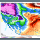
Polar vortex swirls south for significant cold snap
What we're watching: There is also the increasingly likely prospect of a major Arctic outbreak hitting the Lower 48 states beginning late this week.
- The frigid air is associated with a lobe of the tropospheric polar vortex that is slated to break off from its Arctic origins and blast southward.
- Like the coast-to-coast storms, it could affect much of the Lower 48 states before temperatures moderate again.
- Multiple computer models are projecting that extreme cold will be associated with this feature, with temperatures as frigid as 50°F below average or more for mid-January in some spots.
- This may be the coldest air mass to affect many parts of the U.S. in several years. The first areas to see the ultra-cold air are likely to be the northern Plains and Pacific Northwest.
There are numerous studies that suggest polar vortex excursions may be becoming more likely in a warming world, but this is still an area of active research.
The intrigue: If the Arctic outbreak plays out as projected, it would set up a sharp temperature gradient across the country, giving an extra boost of energy to the coming series of winter storms and others to follow.
- The next two weeks of extreme weather events could define the winter of 2023-24 and be one of the most active periods of winter weather for the U.S. in recent years.
The bottom line: It will be difficult for federal, state and local leaders to prepare for and recover from multiple storms and plunging temperatures. It's a test for warning systems and infrastructure while offering a preview of what may be to come during a stormier, extreme weather world.