Northeast winter storm ushers in an extreme weather week
Snow continues on Sunday in Southern New England as the first in a series of storms affects the East Coast.
Threat level: This storm is just the start of an extreme and dangerous weather week across the country that could feature nearly every weather hazard, from flooding rains to hurricane force winds and blizzard conditions.
- The National Weather Service is already sounding alarms about a follow-up storm early this week that will usher in a potentially record-breaking, expansive and long-lasting Arctic outbreak for the Plains and parts of the West.
The latest: The weekend event featured mainly rain from D.C. northward into Philadelphia, with 0.2 inches of wet snow falling in New York City.
- Central Park's streak of going nearly two years without more than an inch of snow in Central Park continues. However, the storm dumped upwards of a foot in northwestern New Jersey, parts of Pennsylvania and New York's Hudson Valley.
- As of Sunday morning, Boston had seen just a trace of snow, but with more on the way, still stands a chance of beating last season's biggest snowstorm of just 3.5 inches.
The big picture: The storm system affecting the heavily populated Amtrak Acela corridor is the result of multiple atmospheric disturbances combining forces and tapping into moisture from the Gulf of Mexico, as well as the Atlantic Ocean.
- On Sunday, as the storm ends from New York southward, jet stream energy aloft is causing the area of low pressure, which is located close to Nantucket, to slow down and intensify.
- This is causing temperatures to quickly plummet across eastern Massachusetts, resulting in what the National Weather Service calls a "flash freeze," and produce a second period of heavy snowfall.
The intrigue: While the NWS is busy forecasting this storm, its experts are already gearing up for what could be an unusually intense winter weather event early next week, which this time would bring blizzard conditions to parts of the Central Plains and Midwest, including St. Louis and Chicago.
- The same weather system may spark severe thunderstorms across the Southeast, along with heavy rain, damaging winds and coastal flooding in New England.
- It is possible that record high levels of water vapor for this time of year could move up the East Coast during that storm, yielding extreme precipitation totals that could cause urban and river flooding.
- Computer model projections also show the potential for widespread damaging winds across multiple states as the area of low pressure quickly intensifies and moves across the Great Lakes region and into Canada.
Of note: Human-caused climate change is making heavy precipitation events like the upcoming one more extreme and frequent, since higher ocean and air temperatures allow for storms to tap into more moisture.
- Sea level rise driven by climate change and land subsidence is also making such storms more common and damaging.
What's next: The Midwest blizzard is likely to drag extremely cold air behind it. This would be associated with a piece of the tropospheric polar vortex, which would pinwheel south from Canada.
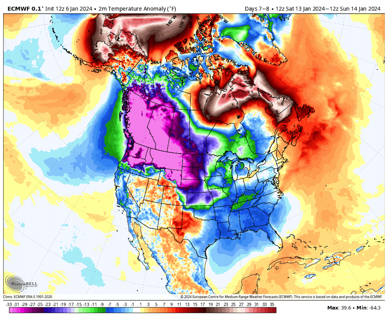
- Some computer models are showing the potential for temperatures to plunge to 50°F below average or colder for mid-January across the Plains and West, potentially including Seattle. This cold may then push south and east, encompassing much of the Lower 48 states within the next 10 days.
- While the intensity of the cold is not yet completely clear, it is evident that a shift to much colder temperatures is likely in the Lower 48 states.
- This cold air is likely to be accompanied by areas of heavy snowfall, and there are indications of another major storm moving from the Gulf of Mexico to the Midwest and East Coast in mid-January.
The bottom line: Few areas of the Lower 48 states will escape the influence of extreme weather in the next week to 10 days.
Editor's note: This story has been updated with the latest conditions.