Ski resorts struggle with winter running late across U.S. and Canada
Ski areas across the U.S. and Canada are in increasingly desperate need of natural snow for a ski season that typically would already be in full swing.
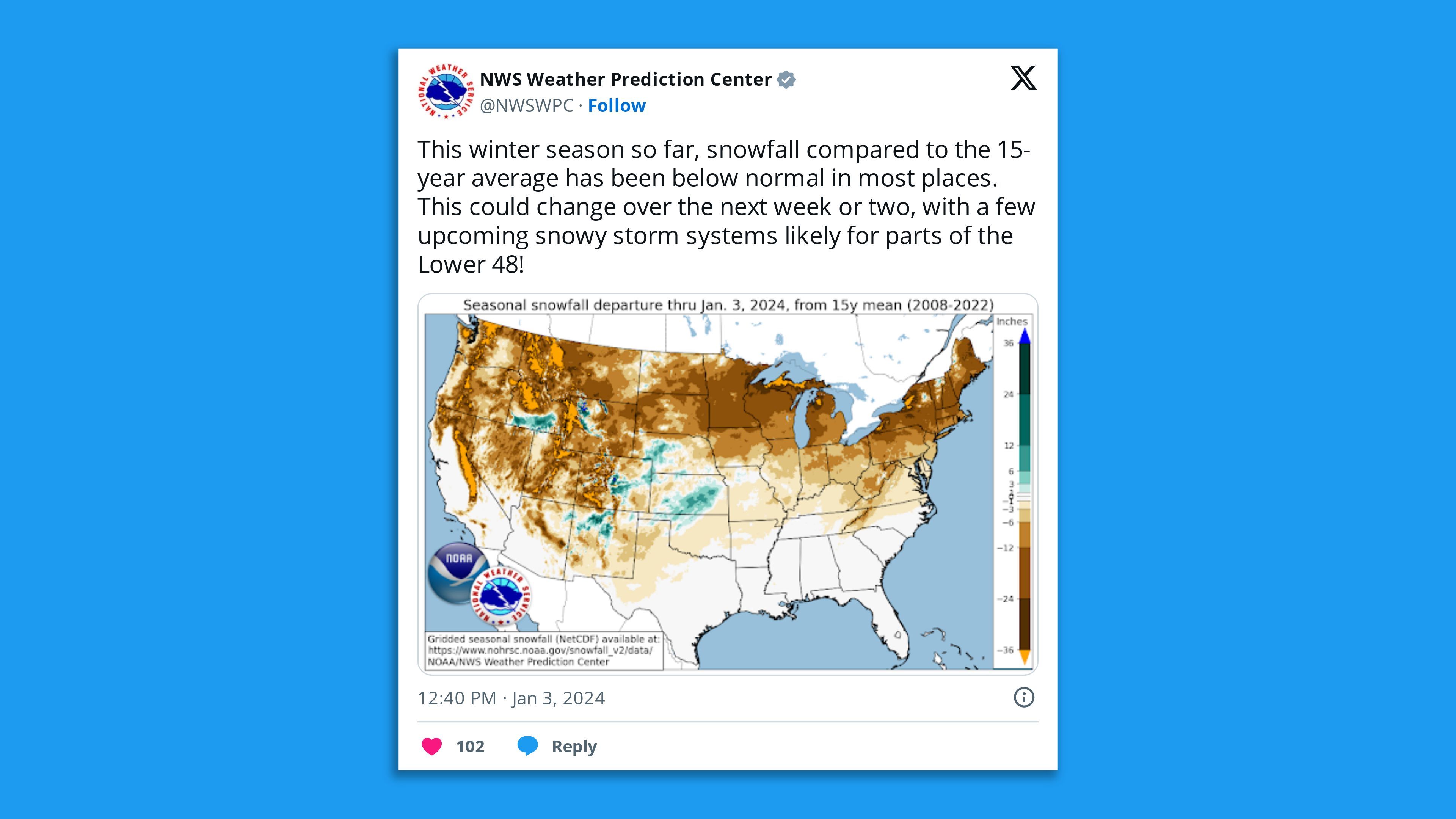
The big picture: From the West Coast of the U.S. and Canada on eastward, milder and drier than average conditions have prevailed, preventing resorts from building up a wintry base for would-be skiers.
- This season offers a preview of future winters, as the season warms faster than any other, partly in response to human-caused climate change.
Zoom in: The strong El Niño in the tropical Pacific Ocean is affecting weather patterns globally and can lead to unusually wet conditions in the West.
- This can be a huge boost to mountain snow cover there if temperatures are cold enough; so far this year, the right conditions have not come together yet.
- Instead, the Sierra Nevada has seen an anemic start to its snow season, with bare ground visible between patches of the white stuff on satellite imagery.
- In British Columbia, ski resorts large and small are seeing below-average snowfall. Whistler Blackcomb resort outside of Vancouver has just 57% of its 10-year average summit snow depth, according to CBC news.
- As of Wednesday, snow cover in the Lower 48 states was at its lowest level since at least 2004.
The latest: The late start to winter is also affecting ski areas in the Mid-Atlantic and Northeast, which have mainly relied on human-made snow to keep trails open.
- This weekend looks to feature first potentially significant winter storm of the season from Pennsylvania to southern New England, but with a potentially wetter, milder storm to follow it that could wash much of the new snow away.
- The U.S. just had its warmest December on record, with the Twin Cities coming in at 12°F above average for the month — an unusually large temperature anomaly for any month.
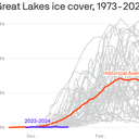
- The Great Lakes had the lowest New Year's Day ice cover in at least 50 years. On Wednesday it was still just 0.36%, compared to the seasonal average for the date of 9%.
- However, it is still early in the season, and ice varies considerably from year to year.
But studies show that winters are changing in many areas across the country, with snowfall declining particularly in areas at the margins of past winter storms, such as the nation's capital, which had just 0.4 inches of snow last winter.
The intrigue: Tied to human-caused climate change, winter is the fastest-warming season in much of the U.S., particularly in northern areas.
- This shrinks the ski season both at its front and tail ends and imperils other forms of winter recreation as well.
- Low elevation ski areas are most at risk, climate studies have shown, but trends are detectable across the board as storm systems start to bring more heavy, wet "cement" snow and rain falls at higher elevations than it used to.
- As seen this year, skiing is becoming less reliable during the holiday season in the East in particular, which hurts economies dependent on tourism revenue.
Context: According to the recent Fifth National Climate Assessment, as temperatures warm, "the fraction of precipitation falling as rain instead of snow will increase."
- In fact, precipitation data shows that nearly 80% of hundreds of measuring locations in the Lower 48 states have seen a decline in the proportion of precipitation falling as snow from 1949-2020.
- "Most historical snow-observation records already show trends toward earlier peak snowpack, smaller volumes, and decreasing snow-season duration," the report stated.
- This poses particular risks in the West, where seasonal snow cover is the main source of water runoff.
Yes, but: The current early season snow drought is likely to prove transient, since it would only take a wobble of the polar vortex and related jet stream shifts — or a series of storms — to deposit a more significant snowpack across North America.
- In fact, the polar vortex, which is an area of low pressure at upper levels of the atmosphere typically located above the North Pole during the winter, is projected to stretch and potentially weaken later this month.
- If this takes place, it would open the Northern Hemisphere's refrigerator door to allow colder air and snowstorms to spill into Canada, the U.S. and Europe.
The bottom line: Weather variability, including the polar vortex, and El Niño are big players in the ongoing lackluster snowpack. Yet what is occurring now is a glimpse into an increasingly wet, rather than frozen, future.