East Coast storm likely to bring long-awaited snow this weekend
The long-running snow drought from Washington to Boston is likely to end, or at least ease, as a winter storm develops, strengthens and moves across the region this weekend.
Threat level: The event does not look like a major snowstorm for D.C., Baltimore or Philadelphia, but the New York to Boston corridor stands a much higher chance of receiving a more significant, plowable snowfall.
The big picture: The storm system likely to affect the heavily populated Amtrak Acela corridor is projected to spin up from a combination of atmospheric disturbances moving across the country.
- Into the weekend, these will tap into moisture from the Gulf of Mexico and the Atlantic Ocean, as well as jet stream energy aloft.
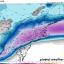
- Snow, sleet and rain are expected to overspread the mid-Atlantic region on Saturday, including Washington, Baltimore and Philadelphia. A coating to an inch of snow is possible in these cities on the front and back sides of the storm, with heavy rain falling in between.
- Areas well to the north and west of the Washington to New York City region could see 6 to 10 inches of snow from this storm.
What we're watching: By Sunday, the winter storm is likely to prove disruptive for travel from central and eastern Pennsylvania northeastward to the Hudson Valley, with airport delays possible in the big cities due to mixed precipitation, low clouds and gusty winds.
- Hartford, Connecticut, and Boston stand the best chance of seeing more than 6 inches of snow out of this storm, since the low-pressure area is projected to intensify significantly as it moves to the south of this region.
- The National Weather Service in Boston predicts the highest odds of 8 inches or more of snow will be just to the northwest of the Interstate 95 corridor, with snowfall amounts in downtown Boston ranging from 4 to 6 inches.
- In a forecast discussion Thursday afternoon, the NWS Boston office noted that recent computer model trends have shown an increasing probability of heavy snow for parts of southern New England, along with strong winds.
- In fact, a foot of snow is not out of the question from this storm in some higher elevation areas of New England, based on computer model projections.
Context: The region that will be affected by this snowstorm has not seen more than an inch or two of snow in as long as two years.
- For example, in Washington, last winter brought just 0.4 inches of snow to Reagan National Airport, which was more than a foot below average.
- In New York City, Central Park last saw an inch of snow in February of 2022. And in Boston, the biggest snowstorm last winter was just 3.5 inches.
- The Boston and New York City streaks have the greatest chance of being broken.
- El Niño winters can bring significant East Coast snowstorms, particularly across the mid-Atlantic. So if this one is mostly a rain event, there may be more chances of snow ahead.
What's next: This storm marks the beginning of a stormy period of weather for the Lower 48 states, with a Midwest blizzard likely by midweek next week, and a potential Arctic outbreak to follow.
Editor's note: This story has been updated with additional details.