Turkey-Syria Earthquake: See How Advanced Mapping Tech Could Aid Rescuers | WSJ
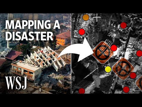
The series of earthquakes that struck Turkey and Syria saw roads blocked or destroyed, hampering rescue efforts. Now, technology such as drones, satellite mapping and computational modeling could be used to help rescuers navigate the destroyed terrain and restore a country's transport network.
Here’s how advanced mapping technology could help the earthquake rescue effort.
0:00 Earthquakes can lead to roads being destroyed or blocked
0:29 Drones can help understand the immediate problem
01:05 Satellite imaging can help map out which paths are blocked
02:13 Modeling can help establish which routes are at risk
George Downs is a WSJ video journalist exploring the future of transport and how technology is changing how we get from A to B. Click here to watch more: https://www.youtube.com/@GeorgeDownsWSJ
#Turkey #Syria #WSJ