California's deadly deluge is not over yet, forecasters say
California may have had a brief respite from widespread flood watches on Thursday, but officials are warning that upcoming storms this weekend are expected to push into next week.
The big picture: Much of central and Southern California is enjoying a brief break from the deadly bouts of atmospheric river events that have sent rivers above flood stage, caused mudslides and debris flows, and killed at least 19 since late December.
- Around 20,000 people are without power while roughly 6,000 remain under an evacuation order, according to the California Governor's Office of Emergency Services.
- FEMA Commissioner Deanne Criswell said at a news conference Friday afternoon that the storm system is still very dynamic and dangerous and encouraged California residents to prepare themselves for the next week.
What’s next: Another atmospheric river is affecting the northern part of the state today and will bring heavy rain and snow to the Pacific Northwest.
- By Saturday, a separate storm is forecast to strike hard-hit areas once again, including San Francisco and Sacramento, with at least a few more inches of rain.
- The San Francisco Bay area may see rain fall heavily but intermittently throughout the weekend.
- More moderate-to-heavy rain is forecast through midweek next week, all the way south to Los Angeles.
What they’re saying: “The storm door remains wide open,” the NWS Bay Area forecast office stated in an online discussion today.
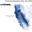
Key stat: So far during the onslaught of atmospheric river events, which studies show climate change is making more intense, the entire state has seen at least 400% to 600% of average rainfall for this time of year.
- Climate change is also accentuating hydrological whiplash events in an already variable state, research shows.
By the numbers: Some locations in the Sierra Nevada Mountains have seen well over 100 inches of snow during this period, sending the statewide average snowpack to 226% of average for this time of year, and 102% of average compared to the typical seasonal peak on April 1.
- The most recent event alone, which finally ended yesterday, dumped its heaviest rains on south-facing mountain slopes in Southern California.
- A staggering 18.78 inches of rain fell in Ventura, 18.31 inches in Nordhoff Ridge and 17.17 inches in San Marcos Pass, per the NWS.
Yes, but: Though the next few storms may not be quite as strong as the most damaging atmospheric river events to date, any additional rain on top of saturated soils will cause additional flooding.
The bottom line: California's flooding woes are far from over.
Editor's note: This story has been updated with additional developments. Axios' Shawna Chen contributed to this report.