Atmospheric rivers sweeping West Coast trigger flooding and power outages
An atmospheric river event is sweeping the U.S. West Coast this week, bringing with it heavy rains, powerful winds and snow.
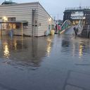
The big picture: The storm system triggered flooding in parts of Northern California, Oregon and Washington, leaving an estimated 190,000 customers without power early Wednesday. Forecasters warned more atmospheric rivers packing large amounts of moisture were expected later this week.
- This "series of Pacific storm systems will affect the western U.S. with heavy rain, mountain snow and strong winds into the weekend," per a National Weather Service advisory Monday morning.
State of play: All 11 states in the Western U.S. were under weather alerts due to the storm, which began to slam the San Francisco Bay Area on Monday night, unleashing heavy rains and powerful winds that resulted in reports of downed trees and flooded roads as the storm system swelled to more parts of California into Tuesday.
- The National Weather Service's Reno office warned of "widespread travel impacts" in the Sierra Nevada, where winter storm warnings were in effect overnight as the bulk of the moisture associated with the atmospheric river began to move southward and wind gusts of up to 151 mph were recorded.

Meanwhile, high tides, strong winds and flooding were reported across western Oregon and Washington state on Tuesday.
By the numbers: More than 128,000 customers were without power in Oregon, along with nearly 40,000 in Washington early Wednesday, according to poweroutage.us.
Of note: Officials in Olympia reported a high tide record of 18.4 feet as jellyfish were reported washing into the streets of Washington's state capital.
What to expect: The "deep and fast-moving storm system sweeping through the Intermountain West" overnight was expected to continue unleashing moderate to locally heavy rain across the West Coast and parts of southern and central California through early Wednesday, per the NWS.
Threat level: "A few scattered flash floods are possible, with the greatest chances for rapid runoff and debris flows near recent burn scars," the weather service warned.
- "Additionally, heavy snow is possible throughout the higher terrain of the Sierra Nevada, Cascades, northern and central Rockies as moisture flows eastward along a potent Pacific jet streak."
What's next: "After a brief lull on Wednesday, the next system to move onshore the West Coast is anticipated to begin spreading precipitation inland on Thursday," the NWS said.
- "Additional heavy rain from central California to the Pacific Northwest is forecast, along with another round of moderate to heavy mountain snow. This unsettled weather pattern is expected to linger into the upcoming weekend as well."