Subtropical storm Nicole could hit Florida as a hurricane by midweek
Subtropical Storm Nicole, currently spinning just over 400 miles from the Bahamas, is forecast to intensify and strike Florida at or near hurricane intensity midweek.
Why it matters: The storm's intensity may be deceiving, as its large size is likely to make it a high-impact event with damaging coastal flooding, dangerous winds and heavy rainfall across a broad region.
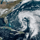
Driving the news: The center of Subtropical Storm Nicole was located about 415 miles east-northeast of the northwestern Bahamas as of 1am ET Tuesday. It was moving northwest at 7 miles per hour with maximum sustained winds of 45 mph.
- Air Force reserve hurricane hunters were investigating Nicole's large wind field early Tuesday, the National Hurricane Center said.
Threat level: Subtropical storms are hybrid systems with characteristics of tropical and non-tropical storms. Importantly, they tend to have a large wind field, which will come into play with the storm's impacts in Florida.
- The storm is forecast to slowly intensify, and transition into a tropical storm during the next two days. Eventually, Nicole is forecast to become a Category 1 hurricane shortly before making landfall on the east coast of Florida, somewhere near West Palm Beach, between Wednesday and Thursday.
Yes, but: The landfall location is less important in the case of this storm, since its winds will reach all the way to the coast of Georgia, bringing high surf, beach erosion, storm surge flooding, damaging winds and heavy rains.
- If Nicole comes ashore as a hurricane, it would be the latest such storm to strike Florida, according to Michael Lowry, a hurricane specialist and storm surge expert at WPLG-TV in Miami.
Zoom in: Gov. Ron DeSantis on Monday declared a state of emergency in 34 counties "in an abundance of caution" to allow residents to prepare necessary resources in the event the subtropical storm gains strength.
- “While this storm does not, at this time, appear that it will become much stronger, I urge all Floridians to be prepared and to listen to announcements from local emergency management officials,” DeSantis said in a statement.
The National Hurricane Center has issued a hurricane watch for the east coast of Florida from the Volusia County boundary with Brevard County to Hallandale Beach and for Lake Okeechobee.
- A storm surge watch is in effect from the east coast of Georgia south to Hallandale Beach, Florida.
- The NHC stated that hurricane conditions are possible in southeast to east-central Florida beginning Wednesday, while tropical storm conditions can be expected beginning Wednesday across a larger area of Florida and Georgia.
- "A dangerous storm surge is possible across portions of the northwestern Bahamas, much of the east coast of Florida and portions of coastal Georgia," the NHC stated in a forecast discussion. "The storm surge will be accompanied by large and damaging waves."
Between the lines: NHC forecasters are cautioning against focusing on Nicole's track, stating the storm "is expected to be a large storm with hazards extending well to the north of the center, and outside of the cone, and affect much of the Florida peninsula and portions of the southeast U.S.
- Much of Florida, particularly areas along the east coast, will be threatened with urban and river flooding from the storm as well, given that it will be moving slowly across the state and then turning north towards the southeastern coast.
Go deeper: Hurricane Ian may have been Florida's costliest storm
Editor's note: This story has been updated with a statement from Florida Gov. Ron DeSantis and details of the storm's movement.