Weekend blizzard to smack Montana with reality check
Published Date: 11/4/2020
Source: news.yahoo.com
After witnessing record-breaking snowfall in mid-October, residents of Montana are likely to get another reminder of the brutality of the state's winter weather as forecasters are predicting that a blizzard will unfold over the weekend.
Native residents are familiar with Montana's long winters, with winter storms, and even blizzards, occurring as early as October and as late as May. Just this past month, records fell across the western United States as a historic cold snap buried some cities in up to 25 inches of snow. Other cities had grand temperature departures from their previous daily records.
CLICK HERE FOR THE FREE ACCUWEATHER APP
Among these cities was Bozeman, Montana, which has specifically seen an influx of transplants over the years, but the migration of big city dwellers to the area has seemingly intensified during the coronavirus pandemic.
Missoula, Montana, another city experiencing an influx of transplants, is now expected to get its fair share of an early blizzard.
This will be quite a dramatic change, which is not uncommon in this part of the country, especially in the spring and fall.
"In the northern Rockies, temperatures have been more representative of late September than early November," said AccuWeather Senior Meteorologist Mike Doll.
Many areas in the northern Rockies had an unusually snowy October. Great Falls, Montana, had 28.0 inches of snow, easily surpassing the old October record of 18.5 inches set in 1925. However, that snow is now a distant memory given the unseasonable warmth during the past week.
"With the exception of the mountains, all of the snow that fell during the last half of October in the northern Rockies has melted," Doll stated.
The upcoming change in the pattern will be due to a large dip in the jet stream. When the jet stream plunges, cold air from the north is free to pour southward. Without any large bodies of water to warm the air -- as often occurs farther east around the Great Lakes this time of year -- temperatures could be nearly as cold in the U.S. as in Canada.
And, it won't be cold and dry with this blast of wintry weather. A storm system over northeastern Oregon will trigger precipitation across portions of the West, beginning on Friday. Snow is expected to thump in the Sierra Nevada in California, where snow has yet to fall this season.
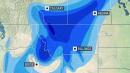
From there, the weather system will move northeastward, intensifying as it does so. Cold northwesterly winds will cause temperatures to tumble further. As precipitation develops in the northern Rockies, it will fall in the form of snow. The heaviest snowfall will occur Saturday night and Sunday. As the storm become stronger, winds will intensify as well.
Blizzard conditions could develop in western Montana during the day Saturday as winds strengthen. Then, conditions are predicted to deteriorate with blizzard conditions possible farther east across central and eastern Montana on Sunday.
"Snowfall rates of an inch per hour or more combined with strong winds will create very poor visibility and difficult travel conditions," Doll cautioned.
Winds are expected to howl at 40 to 60 mph, with the potential for blowing and drifting of snow to add to the travel dangers.
Several inches of snow are expected to fall over a wide swath. However, in many locations, the snow is likely to be measured in feet. Forecasters are predicting an AccuWeather Local StormMax™ of 48 inches of snow from Friday into Monday morning.
Temperatures are expected to take a dramatic nosedive as the storm progresses.
In Glasgow, Montana, temperatures will drop from the 50s F on Saturday to the 30s by Sunday morning. Temperatures will continue to plummet all day Sunday and will end up in the teens by Monday morning.
Even where snow does not fall farther to the south, strong winds could cause issues. The Great Basin and southern Rockies are in the grips of a drought, and increased winds could create tough conditions for firefighters battling the numerous wildfires that are burning. AccuWeather Local StormMax™ wind gusts are expected to reach 80 mph.
After the snow winds down across the northern Rockies early next week, temperatures will remain below normal. Therefore, the snow will not be so quick to melt this time around.
Justin Iverson, 43, a third-generation cattle rancher in Potomac, an area that's about a 30-minute drive east of Missoula, raises cattle that "do handle the cold quite well," he previously told AccuWeather in an email.
Iverson and his wife own Iverson Ranch and partner with his aunt and uncle to run the ranch. Although his family was originally from Minnesota where they operated a dairy farm near Kasson and Mantorville, Iverson was born in Montana and raised on the same ranch he now runs.
A cross of Red Angus and Simmental/Gelbvieh cattle, Iverson's herd routinely endures temperatures of minus 30 F through January and February, he said.
"The cows adapt to the cold by growing a dense layer of thick hair in the fall and shed it in the spring before summer season," Iverson explained. Around this time of year, he said, the cows are typically busy grazing in the hay meadows, but with the early snowfall limiting their access to grass, Iverson will throw them alfalfa hay until the ground thaws out.
Keep checking back on AccuWeather.com and stay tuned to the AccuWeather Network on DirecTV, Frontier and Verizon Fios.